by Jon Anderson
CandysDirt.com
[Editor’s note: Jon Anderson is a columnist for CandysDirt.com. His opinions are his own.]
While Thursday’s meeting fell short of the usual fireworks expected, the City Plan Commission asked some great questions regarding city staff’s proposed changes to PD-15.
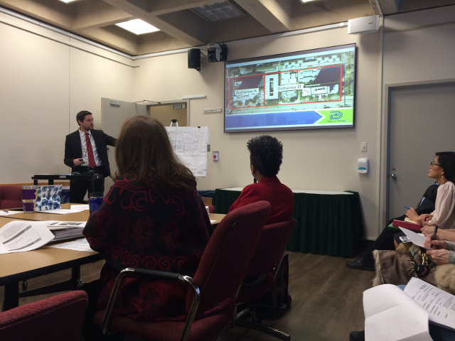
In the lead-up to City Plan Commission’s public hearing on staff’s proposal for updating PD-15, staff briefed plan commissioners Thursday morning at Vital. Groups. Knee. Senior Planner Andrew Ruegg, who’s led the process so far, presented essentially the same slides as were shown to the community two weeks ago.
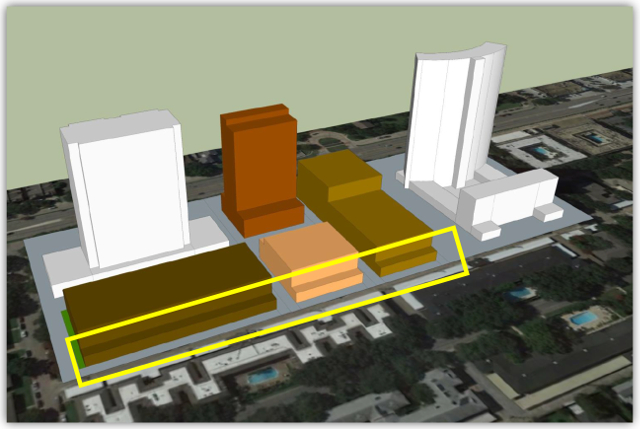
What the few who went to the meeting were most interested in were the questions and comments from the other commissioners. I give a “Hallelujah!” to CPC chair Gloria Tarpley for commenting that the 3-D images shown of the proposed changes would have been welcome at other cases. How the city can be devising “words on paper” documents reflecting 3-D realities without 3-D models has always been a mystery. It should be ante to the game.
The first questions were from District 11 appointee Janie Schultz. First, she was curious whether the requirement for a street lamp every 50-feet was adequate. While boilerplate, staff said they’d look into it. Schultz’ second question concerned the affordable housing sweeteners and whether anyone would use them. The suspicion is that along the northern side they will be unlikely to be used, while on the Northwest Highway side they may if the developer wants to get near tapping any height. It kind of goes to what I’ve been saying that if the buildable envelope doesn’t grow, it’s just cannibalizing market-rate units for affordable units.
Commissioner Jung was next (at least I think it was, his back was to me). He wanted to know what would happen to all the non-conforming things that would result if the proposed changes were adopted. He called out the carports on the PD’s northern alley, two caretakers’ cottages-turned-condo, and the towers themselves (which would violate the proposed residential proximity slope). The answer was essentially nothing would happen until a property redeveloped.
Commissioner Shadid followed up Schultz’ comments on the usability of the proposed affordable housing sweeteners. Ruegg wouldn’t comment specifically on their likelihood of use.
District 14 appointee Paul Ridley focused on the burned Preston Place lot. He wanted to know if their existing footprint was grandfathered in. It appeared the current Tulane Blvd. buildable lot line would encroach on the proposed setbacks – should someone want to rebuild the old Preston Place exactly as it was. It got mildly confusing when Ridley seemed to mix the 66 surplus lots into Preston Place’s original 60 units. City staff didn’t seem to understand Ridley’s apparent misunderstanding. For clarification, Preston Place’s 60 units are not part of the 66 surplus units (which are a shared resource among the other PD-15 parcels). The surplus units are the result of PD-15 being changed to reflect the density of a never-built high-rise on Preston Place. When that planned 125-unit complex only resulted in the 60-unit Preston Place, the shared resource of today’s 66 surplus units was created because the PD was never changed to remove the unbuilt units.
The final commissioner to ask a question I’ll leave nameless because the question was embarrassing. This commissioner wanted to know how the area would be replatted should a single-family home builder wish to develop within the PD. I call it embarrassing because no one is going to pay the land price only to plop what would he hugely expensive homes in the middle of a neighborhood that on a generous day would be called middle-class. Although, never say never. In 2006, someone built townhouses in Farmers’ Market on land zoned CA-1 providing unlimited height, 100 percent lot coverage, and 20-to-1 density.
Now, since the public wasn’t allowed to speak, here are my two suggestions …
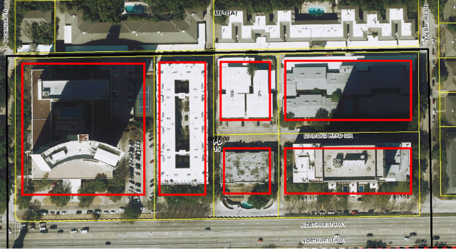
Proposed setbacks outlined in red
Northwest Highway Setbacks
From above, it’s easy to see the structure of the four Northwest Highway-facing buildings are essentially in alignment. There’s a reason. In 1945, “Preston Tower” was called out on a city survey and notes the 100-foot setback minimum. In 1963 there’s another survey that extends the 100-foot setback across all four parcels. In 1966, a contract was signed by each of the four parcel owners that called out the 100-foot setback and the 50-foot right of way – it states changes must be unanimously approved. Each owner’s title documents list the 100-foot setback.
Today, there are two parcels who could feasibly take advantage of a reduced setback. Preston Place has a roughly two-acre parcel and so given its size, doesn’t need it to build a good building. Royal Orleans is a small parcel with an equally small buildable envelope. Should one building be pulled out of alignment? And for what?
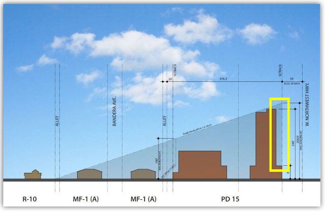
Even assuming it was legal (which seems doubtful), the proposed 70-foot setback guarantees a poor pedestrian experience. As seen in the yellow box above, the 70-foot setback is only good for the first 45 feet in height. Above 45 feet, the Northwest Highway urban form setback of 20-feet kicks in, producing a 90-foot setback above 45 feet in height. The only benefit of the 70-foot setback is to the first 45-feet of a potentially 240-foot tall building – you know, where the pedestrians are supposed to be.
Reviewing the numbers, the proposed changes call for 10 feet of (pink) wall/green space border along Northwest Highway. There’s a 50-foot public access frontage road. A 70-foot setback is 10 feet back from the frontage road. But wait, the plan also calls for up to 15 feet of encroachment for porticos and such. Someone’s missing 5 feet.
The result is that the neighborhood winds up with a landing strip of sidewalk and the occasional bush flanked by neighbors who, while having porticos, also have pretty good front yard landscaping. The towers also use the 100-setback for drop-off outside the active roadway. By comparison, a 70-foot setback would result in road-blocking drop-offs.
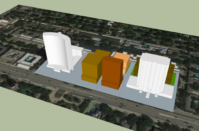
The solution here is obvious. If the urban form setback along Northwest Highway is ditched, it results in a flat face to Northwest Highway (boo-hoo) that if pushed back to the 100-foot line results in a potential building having the same (or more) buildable square footage without messing up the very streetscape the plan is trying to engender.
A four-story encroachment into the 100-foot setback is a poor exchange for an urban form setback that benefits no one (that would be challenged in court).
Multi-Family Residential Proximity Slope (RPS)
On the northern boundary is another setback that needs looking at. While I’m all for the single-family RPS being instituted, the multi-family version will cause unintended results. The goal for the “back” northern lots is to keep them lower than those on Northwest Highway – it provides a needed step-down between the existing height on Northwest Highway and the two-story developments to the north. Lower buildings also tick-off the existing towers less.
Single-family RPS does this just fine. What multi-family does is knock off the lower floor backs of potential buildings along an alley. The existing buildings across the alley are two-story with bedroom windows facing towards the alley. The ground-floor windows of those buildings are below the corrugated steel carport roofline – their “view” is of a car hood and a white painted steel sky. If a 100-story building was built, the views from those windows are unchanged. The second-floor windows are rarely unobscured by curtains or shutters, signaling their view is already not worth viewing. Being zoned MF-1 and deed restricted on top of that, change across the alley is extremely unlikely.
BUT, if the multi-family RPS chunks out enough of the lower floors to force a building to go higher due to less efficient geometry, that’s a poor trade-off for the neighborhood. For example, because the dimensions are known, would the currently proposed 85-foot Diplomat replacement be forced to jump up to a full 8-stories to make the geometry work? I don’t think there’d be much neighborhood support for an extra floor in exchange for the multi-family RPS. Especially when it impacts an alley and buildings whose poor views are likely to be impaired further. However, an extra story will make them darker as more sky is taken.
There are nuances to setbacks whose cost/benefit to the resulting neighborhood should be considered more closely.
View article online
